


From PennDOT and the US National Weather Service
Ahead of anticipated winter weather across the state Saturday into Sunday, the Pennsylvania Department of Transportation (PennDOT) and the PA Turnpike Commission (PA Turnpike) are advising motorists to avoid unnecessary travel during the storm and to exercise caution when driving. Additionally, PennDOT and the PA Turnpike will implement various speed and vehicle restrictions throughout the storm.
Beginning Saturday afternoon, a mix of snow, sleet and freezing rain will move across the state. Temperatures at or below freezing will result in potentially icy conditions. PennDOT and PA Turnpike crews will actively pre-treat roadways where necessary ahead of the storm to help prevent ice from forming a bond with the pavement. However, salt does not resolve all risks, and drivers may encounter icy spots on the roadway. With freezing temperatures, roads that look wet may actually be icy, and extra caution is needed when approaching bridges and highway ramps where ice can form.
Restrictions are planned for certain vehicles during the storm, and will be communicated via variable message boards, the 511PA traveler information website and smartphone apps. Motorists can also sign up for personalized alerts on the website. Restrictions will be lifted as quickly as possible when conditions are safe. Restrictions can be changed based on conditions on the roadways, and reports from first responders, law enforcement and PennDOT and PA Turnpike personnel.
The following vehicle restrictions are planned to go into effect at 3:00 PM on Saturday, February 8, in accordance with Tier 2 of the commonwealth’s weather event vehicle restriction plan.
Interstate 70 from PA Turnpike I-76 to the Maryland border.
I-80 – I-79 to Exit 173 Lamar (PA-64)
I-81 from PA Turnpike I-76 to the Maryland border.
I-99, full length.
PA Turnpike I-70/76 from the New Stanton exit to the Breezewood exit.
Route 22 from I-99 to Route 119.
Route 219 from the Maryland border to Route 22.
The following vehicle restrictions are planned to go into effect at 7:00 PM on Saturday, February 8, in accordance with Tier 1 of the commonwealth’s weather event vehicle restriction plan.
I-81 from Clark Summit (Exit 194) to the New York border
Under Tier 1 restrictions, the following vehicles are not permitted on affected roadways:
Tractors without trailers.
Tractors towing unloaded or lightly loaded enclosed trailers, open trailers or tank trailers.
Tractors towing unloaded or lightly loaded tandem trailers.
Enclosed unloaded or lightly loaded cargo delivery trucks/box trucks that meet the definition of a CMV.
Passenger vehicles (cars, SUV’s, pickup trucks, etc.) towing trailers.
Recreational vehicles/motorhomes.
School buses, commercial buses and motor coaches.
Motorcycles.
Under Tier 2 restrictions, the same vehicles are restricted as Tier 1, as well as tractors towing loaded tandem trailers without chains or Alternate Traction Devices (ATDs).
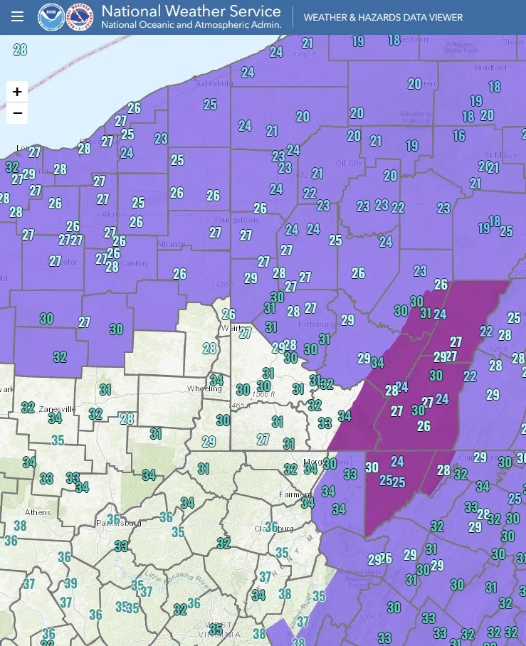
As we wait for precipitation to develop this afternoon, we are closely monitoring surface temperatures, as this will play a big role in where the best threat of icing ends up. Here, you can see current temperatures across the region overlaid on the Winter Weather Advisory (larger purple area) and the Ice Storm Warning area (smaller darker purple area).
Notice the greater number of readings in the 20s in the Advisory/Warning area as opposed to the areas south of Pittsburgh. Warmer air will be moving north into our region this afternoon, but these colder areas will take longer to warm above freezing considering how low they currently are. Also, with lower dewpoints (drier air) at the surface currently, the initial precipitation will likely provide a cooling effect as it falls into the drier air, further slowing the warmup. This supports the expectations for mixed precipitation/freezing rain in the highlighted areas.
We’ll continue to monitor trends closely, and adjustments to the Warning/Advisory areas are possible.


Comments